Maps Services (DWG)
Maps, Topos, Site Plans Drafting 2D
AutoCAD Versions Available: 14, 2000, 2002, 2004, 2005, 2006, 2007, 2008, 2009, 2010, 2012, 2012, 2013, 2014, 2015, 2016, 2017, 2018, 2019, 2020, 2021, 2022
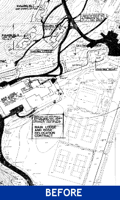
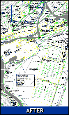
Our maps, topos, and site plans CAD drawings service provides engineers and GIS departments a solution for transferring existing maps into scalable site plan AutoCAD or Microstation CAD files. Types of maps include CAD site plans, landscape plans, topographic maps, contour maps, utility maps, plat maps, sectional maps, aerial maps, GIS maps. Your maps can also include redline markups to show engineering data such as cut and fill calculations, set backs, and field surveys.
Maps are redrafted by QCAD as dimensionally accurate, or in cases of non-dimensioned maps, the sheets are traced to produce an exact overlay of the original document. Adjacent, geographic sheets can be edge-matched to create a composite map region. GIS field survey data can be incorporated, as well as the creation of 3-dimensional contours in topo maps.
Maps are redrafted by QCAD as dimensionally accurate, or in cases of non-dimensioned maps, the sheets are traced to produce an exact overlay of the original document. Adjacent, geographic sheets can be edge-matched to create a composite map region. GIS field survey data can be incorporated, as well as the creation of 3-dimensional contours in topo maps.
AutoCAD 2D DWG File Samples: Maps and Topos
Site Plan (100Kb) Topographic Contour (300Kb) Utility Map (33Kb) Landscape Plan (444Kb)Maps & Site Plan CAD Drawing Services Include:
- AutoCAD (14, 2000, 2002, 2004, 2005, 2006, 2007, 2008, 2009, 2010, 2011, 2012, 2013, 2014, 2015, 2016, 2017, 2018, 2019, 2020, 2021, 2022) – choose version
- Full-scale 1:1
- AIA layering – by layer (American Institute of Architects). Optional: Lite Layering Standards
- Paper space or model space
- Titleblocks, blocks, symbols, hatch patterns match originals
- 100% line connections (no scanning or vectorizing)
- 100% guaranteed quality, accuracy and turnaround
- For each sheet you receive the following file types: DWG file, PDF-color export, PDF-black export, .ctb plot style table, TIF 200 dpi scans of your original document
Send Us Your Project:
AUTOCAD 2D: Maps Services (DWG)
| Size | 4 to 6 Weeks | 10 Days | 5 Days | 3 Days | 1 Day |
| A-Size | $60.00 | $80.00 | $100.00 | $145.00 | $275.00 |
| B-Size | $100.00 | $140.00 | $180.00 | $270.00 | $525.00 |
| C-Size | $230.00 | $330.00 | $430.00 | $640.00 | $1,265.00 |
| D-Size | $230.00 | $330.00 | $430.00 | $640.00 | $1,265.00 |
| E-Size | $230.00 | $330.00 | $430.00 | $640.00 | $1,265.00 |
| A = 9 x 12″ | B = 12 x 18″ | C = 18 x 24″ | D = 24 x 36″ | E = 30 x 42″ |
Turnaround = Business Days
Turnaround options are priced per source document to be drafted into CAD.
Turnaround options are priced per source document to be drafted into CAD.
More about AutoCAD Drafting Services:
Payment Options:
Credit Card:
We accept credit card payments from Visa, Mastercard, Discover and American Express. Your credit card will be billed once the CAD drafting project has been completed. If you are ordering for the first time, you must provide us with a check or credit card for your first order. For active customers, a Net 30 billing account can be arranged.
Check:
Your check payment will be deposited when your construction drafting project has been completed. Check or credit card payments are required for first time customers. Make your check payable to Q-CAD Inc.
Purchase Order:
A purchase order number or project number can be supplied for Net 30 billing accounts. Net 30 billing accounts must have Q-CAD pre-approval. (Download: Q-CAD Credit Application)
GSA Contract:
GSA Contract# GS-25F-0051L (expires 09/29/2016)
GSA Contract# GS-25F-0051L (expires 09/29/2016)


